 Frozen Head State Park
Common sense isn't.
Frozen Head State ParkThis was a good, late afternoon hike on a relatively warm
(40-50F), partly sunny, Valentine's day in beatiful Morgan County,
Tennessee, above the town of Petros and Brushy Mountain Prison.
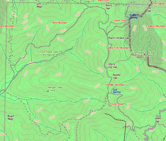
OpenStreetMap of approximate trailhead location.
 There is plenty of free parking on the shoulder of
the paved road at Armes Gap. According to
"http://www.amazon.com/exec/obidos/tg/detail/-/0762702257/">
Hiking Tennessee Trails (worthless amazon affiliate code now deleted) by
Evan Means (at archive) (4th edition, 1994; 5th edition, 1998 is now available),
this route into the park is an old jeep road, which was previously
closed to the public. It is still gated to keep vehicles out, but
three trails (10, 19 and 20) are accessible from here according to
the official park trail map ($3.27 including tax, at the park
office, 423-346-3318). There are no fee collection
stations at Armes Gap.
There is plenty of free parking on the shoulder of
the paved road at Armes Gap. According to
"http://www.amazon.com/exec/obidos/tg/detail/-/0762702257/">
Hiking Tennessee Trails (worthless amazon affiliate code now deleted) by
Evan Means (at archive) (4th edition, 1994; 5th edition, 1998 is now available),
this route into the park is an old jeep road, which was previously
closed to the public. It is still gated to keep vehicles out, but
three trails (10, 19 and 20) are accessible from here according to
the official park trail map ($3.27 including tax, at the park
office, 423-346-3318). There are no fee collection
stations at Armes Gap.
According to
Tom
Dunigan's site (at the time, archive 2004), this route to the fire tower is about 2.8 miles
one-way. (See
new site for updated info) According to the new
looking trail sign, it is about 1.7 miles from Armes Gap to Tub
Springs campsite, plus another 0.5 mile to the lookout tower, for a
total of about 2.2 miles one-way. According to the park trail map,
it is 2.0 miles one-way, moderate difficulty, and takes 1.5 hours
for an average hiker (at 1.5 miles per hour). Considering it was
mostly steady uphill climbing the 1185 feet to the top, and mostly
downhill returning, it felt like 2.8 miles going up and less than
2.0 miles returning. It took me about 1.75 hours going up, at a
leisurely pace with several stops, and about 1 hour returning back
down.
 At
about a half mile from the start, there are a couple forks in the
road. Bear right and uphill for the route to the tower. The first
fork to the left is the Old Prison Mine Trail (trail number 20),
and the second fork to the left is another similar old trail.
Otherwise, the route is obvious all the way to Tub Springs
campsite.
At
about a half mile from the start, there are a couple forks in the
road. Bear right and uphill for the route to the tower. The first
fork to the left is the Old Prison Mine Trail (trail number 20),
and the second fork to the left is another similar old trail.
Otherwise, the route is obvious all the way to Tub Springs
campsite.
There was an old rusty car and some other old "Tennessee Trash" down the side of the mountain (Oak Ridger articles September 1998; and October 1998). (links at archive)
The three windmills at TVA's wind power
plant on the ridge in the distance were clearly visible through
the leafless trees at several spots along the way. Notably,
the air was still, and the windmills appeared to be not spinning
for over 3 hours straight.
 There is a relatively recent,
infamous historical connection with this hike route. James Earl Ray
(Oak Ridger, Who Really Shot Martin Luther
King Jr.?"
February 20, 2004, at archive) and six other prisoners escaped from nearby
Brushy Mountain State Prison in the early evening of Friday, June
10, 1977 (Oak Ridger
May 7,1998 article, at archive). According to Building Time at Brushy by
Stonney Lane, after they followed a creek up the mountain side away
from the prison, three of the escaped prisoners, including Ray,
climbed up "the old Seven Mine road"to the tower road. They then
followed the tower road a short distance before spending the night
hiding in brush and rock overhangs below the road. The next
evening, Saturday, they followed the tower road some more, and then
followed an old strip mine pit and another old mining road down to
the valley bottom near Highway 116 and New River.
There is a relatively recent,
infamous historical connection with this hike route. James Earl Ray
(Oak Ridger, Who Really Shot Martin Luther
King Jr.?"
February 20, 2004, at archive) and six other prisoners escaped from nearby
Brushy Mountain State Prison in the early evening of Friday, June
10, 1977 (Oak Ridger
May 7,1998 article, at archive). According to Building Time at Brushy by
Stonney Lane, after they followed a creek up the mountain side away
from the prison, three of the escaped prisoners, including Ray,
climbed up "the old Seven Mine road"to the tower road. They then
followed the tower road a short distance before spending the night
hiding in brush and rock overhangs below the road. The next
evening, Saturday, they followed the tower road some more, and then
followed an old strip mine pit and another old mining road down to
the valley bottom near Highway 116 and New River.
The creek pictured at right, seen from the tower road, is not the same creek the escapees followed up the mountain side, because it is on the opposite side of the mountain from the prison, but the terrain is probably similar. It also shows a little of the sedimentary layers found all around the area.
It was somewhat colder at the higher elevations near the top of
the mountain, especially on the shaded, northern side. As seen in
the pictures below, taken near Tub Springs campsite, snow was still
on the ground. An advantage to cooler temperatures is rattlesnakes
and copperheads are seldom seen at temperatures below about 60F,
according to the safety tips on the back of the park trail map.
At lower elevations in the area, typical high temperatures
are below 60F from November through March.
 The picture at
left shows the Tub Spring and fireplace, which are made from stone.
Tub Spring looked full of water inside, although I didn't see any
running in or out. I didn't taste the water, but the trail map says
all backcountry water should be boiled before use. According
to
Hiking Tennessee Trails (worthless amazon affiliate code now deleted) by
Evan Means (link at archive) (4th edition, 1994; 5th edition, 1998 is now available),
Tub Spring and fireplace were built by
CETA labor (now at archive) in 1978.
The picture at
left shows the Tub Spring and fireplace, which are made from stone.
Tub Spring looked full of water inside, although I didn't see any
running in or out. I didn't taste the water, but the trail map says
all backcountry water should be boiled before use. According
to
Hiking Tennessee Trails (worthless amazon affiliate code now deleted) by
Evan Means (link at archive) (4th edition, 1994; 5th edition, 1998 is now available),
Tub Spring and fireplace were built by
CETA labor (now at archive) in 1978.
The final pictures below show three views of the area around Tub
Springs campsite. If your screen is wide enough, the three pictures
somewhat make a panorama from left to right, looking more or less
toward the west, north, and east. The first shows the road to the
lookout tower, to the left, and Chimney Top Trail (number 8), to
the right behind the sign. The second picture shows Tub Springs
campsite, in the direction to North and South Old Mac trails
(numbers 4 and 5), Panther Gap Rockhouse trail (15), and to the
north on Lookout Tower Trail (1). Believe it or not, people had set
up a tent and were camping there. In over three hours, I saw
only two people, at the campsite. The third picture shows the road
back to Tub Springs (200 feet from the sign) and to Armes Gap. From
the footprints in the snow, it appeared that numerous people had
hiked from the main park entrance to the lookout tower, but very
few hiked in from Armes Gap.


Related Links:
[ Park Entrance ] [ Armes Gap to Fire Tower ] [ Frozen Head Peak ]
| Quote of the moment |
| >consult guide about small receptacle Part of an atomic vector plotter. >consult guide about long dangly bit The Guide checks through its Sub-Etha-Net database with the following entry: Part of an atomic vector plotter. |
| ~ Hitchhikers Guide to the Galaxy ~ |
Common sense isn't.
Images stored locally for protection of your privacy (unless/until you search with Google). Stomp out web bugs (archive.org).
Copyright © 2000- hal9000[zat]mensetmanus.net
I last touched this page on Monday, 2022-11-07 at 01:40:42 UTC.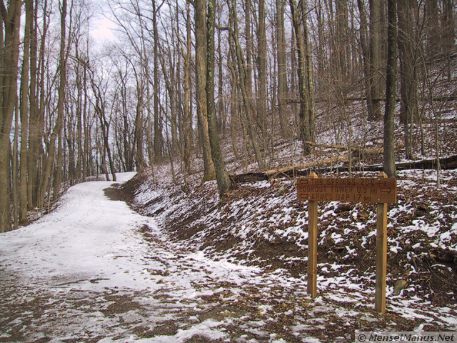