
Common sense isn't.
Also Available - Directions for a longer route to Buffalo Mountain from Route 116 on the northern (Petros) side.
Notes from 4/27/2006: The short route via Windrock was in good shape, with paved road about half the way up, and gravel in good shape the rest of the way.
Notes from 09/05/2004: It's been a long time since my last update. The short route via Windrock is much improved, and I would now consider taking my personal road car. With the Suburban I never needed 4WD on this visit. Access to near the wind power plant is more restricted than previously, as described here (archive, 2004).
One great improvement by the
Windrock ATV Club (archive, 2004) (and/or Coal
Creek Mining Company) is the signs marking roads and trails.
Although not every intersection was marked, most were. Using
Tommy Rhea's
map and the road signs made it much easier to find the
way.
Notes from 6/24/2001: The
Coal Creek Mining
Company (archive, 2004) (warning, slow-loading javascript and pictures;
old archived site) has re-asserted its authority over the land.
They have teamed with the
Windrock ATV Club (archive, 2004) to institute a
Permit (and
fee) system (archive, 2004) for access to the area. Notable improvements
include some cleanup of trash dumps, and signs with difficulty
ratings of roads and trails. Interestingly, there still appeared to
be no controls (signs) from the northern approach to the
area.
 If you have a 4-wheel drive vehicle, or at
least something with high clearance underneath, you might want to
go for a visit. You could also take a hike or
bike ride up
the approximately 6 miles of road from the church in Windrock.
If you have a 4-wheel drive vehicle, or at
least something with high clearance underneath, you might want to
go for a visit. You could also take a hike or
bike ride up
the approximately 6 miles of road from the church in Windrock.
Other places you could visit in the general area include Frozen Head State Park, (archive, 2006) Big South Fork (archive, 2006) National Recreation Area, Oak Ridge (archive, 2006) - the Atomic City, Knoxville, and the Great Smoky Mountain National Park.
As far as I know, there are no organized tours. On the few times I've been, I've usually seen a government jeep coming or going (I think) to either the communications facility on Windrock Mountain or the power plant on Buffalo Mountain. I suggest contacting TVA to ask them to start running tours ( info@publicpowerinstitute.org ). They took 2 weeks to respond to my inquiry, so be patient.
 No Good Road: The road gets
steadily worse from bottom to top. In a few miles you go from
regular, 4-lane highway, to 2-lane, paved, local road; to 1-2 lane,
rough, steep, pot-holed, paved road; to ~1-lane steep, gravel/dirt,
rocky road. Sturdy Off-Road Vehicles are Strongly
Recommended. Using your regular street car is not advised, but
I have seen them up there. You can probably make it if you're
very careful going over the rocks and holes in the road, but
again, I don't recommend it. Be warned - I have scraped bottom
(rear differential, I think) in a Suburban 4WD, and I've seen a
muffler and tailpipe left behind on the road. I've also seen a big
old sedan driving back down the mountain on a rim (with a flat
tire). On a positive note, there's no posted speed limit.
No Good Road: The road gets
steadily worse from bottom to top. In a few miles you go from
regular, 4-lane highway, to 2-lane, paved, local road; to 1-2 lane,
rough, steep, pot-holed, paved road; to ~1-lane steep, gravel/dirt,
rocky road. Sturdy Off-Road Vehicles are Strongly
Recommended. Using your regular street car is not advised, but
I have seen them up there. You can probably make it if you're
very careful going over the rocks and holes in the road, but
again, I don't recommend it. Be warned - I have scraped bottom
(rear differential, I think) in a Suburban 4WD, and I've seen a
muffler and tailpipe left behind on the road. I've also seen a big
old sedan driving back down the mountain on a rim (with a flat
tire). On a positive note, there's no posted speed limit. On the other hand, they still hold a
miners' re-union at the Union Valley Baptist Church in Windrock
(Oak Ridger Newspaper articles:
10/10/00, (archive, 2002)
and
10/6/00 archive, 2003). I've personally not had any trouble in several visits. Also,
there actually is a roving government jeep around some times.
On the other hand, they still hold a
miners' re-union at the Union Valley Baptist Church in Windrock
(Oak Ridger Newspaper articles:
10/10/00, (archive, 2002)
and
10/6/00 archive, 2003). I've personally not had any trouble in several visits. Also,
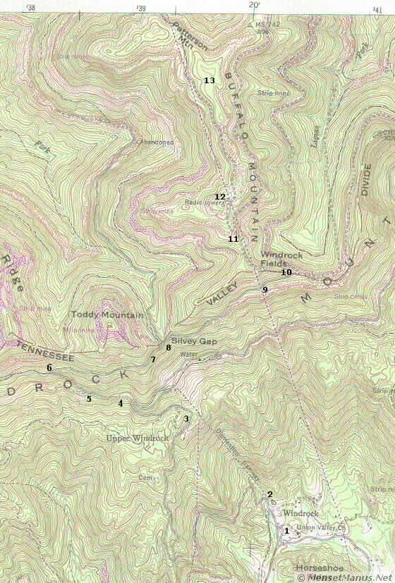
there actually is a roving government jeep around some times.To help with the area beyond Union Valley Church in Windrock, here is a scanned and annotated portion of a USGS/TVA Topographic map with 3 different file sizes (and jpeg qualities): Small File = 50 KB, Medium File = 90 KB, and Large File = 140 KB. The screen size or "Zoom" is the same, but the sharpness or fuzziness differ. See the Related Links below for how to buy a complete map. The annotated numbers correspond to the reference points in the table below. You may prefer the terraserver aerial photos or topographic maps with adjustable zoom, which are linked to in the table below.
The directions begin near Windrock Road and Route 61/62 (OpenStreetMap) in Oliver Springs Tennessee USA . As Tom Dunigan's mountain biking web site says, "Take Windrock Rd out of Oliver Springs just east of the 61/62 junction." This is another example of confusing Tennessee road numbering, where the two routes are together for a few miles. From Oak Ridge, the road is the continuation of Illinois Avenue going towards Oliver Springs.
When you can look over old downtown Oliver Springs to the left, while going over the Southern Railway overpass and curving left , you need to take the next road to the right. There are several small signs for churches, but no street sign. This is also the first right turn after the "Downtown Oliver Springs" exit from the "highway." If you get to the "red light" where 62 goes right toward Frozen Head and Big South Fork, then you've gone too far. Maybe easier directions would be to go to the traffic light where 61 and 62 separate, do a U-turn, and go back one street and turn left.
Bear to the right at a couple intersections while heading towards Union Valley Church. Notice the old oil well rigs along the road as you approach the church. This road is paved and in good shape.
 Approaching the church, bear
left. Follow the road to the left, across the 1-lane bridge over
the creek. Trusting this bridge will be your first test of
confidence. To the right near this spot was the lower end of the
the mine tramway. Although it is now dismantled, a large concrete
block and signs of railroad can still be seen. It is also clear
that the old L&N railroad from Oliver Springs crossed the
creek, and the current roadway, here. This also begins the 1-2
lane, rough, steep, pot-holed, paved road, which goes for about 2.3
miles.
Approaching the church, bear
left. Follow the road to the left, across the 1-lane bridge over
the creek. Trusting this bridge will be your first test of
confidence. To the right near this spot was the lower end of the
the mine tramway. Although it is now dismantled, a large concrete
block and signs of railroad can still be seen. It is also clear
that the old L&N railroad from Oliver Springs crossed the
creek, and the current roadway, here. This also begins the 1-2
lane, rough, steep, pot-holed, paved road, which goes for about 2.3
miles.
Follow the directions in the table below. On the dirt road, you "can't go wrong" if you follow what looks like the more used, main road, and avoid turning off on roads heading downward. Keep your eye out for the really tall radio tower, which you pass about a mile before the wind mills. You can see the radio tower from a long way off, but it is not visible for the whole route.
Final tips: Somebody has painted arrows on the pavement or other conspicuous places at several decision points - follow them (assuming they don't get vandalized). Pay close attention on the way up, because on the way back down everything looks different. On the way down, there are a couple places, particularly the "T's," where you need to remember to turn, rather than going straight.
| Reference Point | Description, Links to |
Miles from Route 61/62 | Miles From Union Valley Church |
| - |
Windrock Road and Route 61/62 |
0 | - |
| 1 | Union Valley Church in Windrock, | 3.3 | 0.0 |
| 2 | 1-Lane Bridge | 3.4 | 0.1 |
| 3 | Open Viewpoint, Upper Windrock | 5.4 | 2.1 |
| 4 |
End of paved road at T take dirt road to left |
5.65 | 2.35 |
| 5 | Bear right - fork to uphill | 5.8 | 2.5 |
| 6 | Bear sharp right - fork to uphill | 6.1 | 2.8 |
| 7 | False Peak | 6.7 | 3.4 |
| 8 | Bear ~ straight, upward | ||
| 9 | Bear right (up fork) | 7.2 | 3.9 |
| 10 | T, go left | 7.4 | 4.6 |
| 11 |
Intersection go straight/left along power lines (ENXCO sign) |
8.1 | 4.8 |
| 12 | Communication Station, radio tower, atop hill at left | ||
| 13 | Wind Power Plant along hill at right (Note vehicle in road in photo) | 9.4 | 6.1 |
| Quote of the moment |
| A schoolboy's tale, the wonder of an hour! |
| ~ Lord Byron, Childe Harold's Pilgrimage, Canto ii. Stanza 2. ~ |
Common sense isn't.
Images stored locally for protection of your privacy (unless/until you search with Google).
Disclaimer Fine Print: This site is personal, and is independent of TVA or any other organization. Use of the abbreviation "TVA" is purely for descriptive purposes (for example, to distinguish from wind power plants on Buffalo Ridge in Minnesota). No endorsement, no approval, and no involvement by TVA is implied.
Copyright © 2000- hal9000[zat]mensetmanus.net
I last touched this page on
Sunday, 2022-11-13 at 05:58:25 UTC.